BENEFITS

Fleet Management Dashboard
  • Easy to use internal dashboard
  • GPS tracking
  • Street Prioritization
  • Track Vehicles on map by toggling Zone
  • Design Vehicle/truck types
  • Activate Vehicles as needed
  • Add unlimited user with specific access levels
Spring, Summer, and Fall
  • FleetPaths 365 can be used year-round.
  • The ability to track pothole repair
  • Rubbish pick up
  • Gravel road maintenance
  • Garbage collection
  • Leaf pick up
Wintertime
  • FleetPaths 365 can be utilized in the wintertime.
  • The ability to track all snow removal for your public and private streets.
  • Salting of roads
  • Track subcontractor plows
  • Ability to monitor salt/plow blade usage
Reports
  • Run reports on when plows were up and down
  • Run reports on salt spreaders and idle times
  • Replay one vehicle or entire fleet from a user defined date and time
  • Use the detailed reporting system to increase productivity in future events
Road Last Serviced
  • Roads are color-coded according to the current status
  • Residents can determine when their roads were last plowed
  • Customized color and time periods to show

BENEFITS

Truck Image
Benefits
    Efficency
  • Reduce costs with telematics
  • Enhance Safety
  • Monitor fleet safety in real-time
  • Snowpaths is fully and easily intergrateable with Verizon Connect
  • Compliance
  • With reporting, make it easy to manage efficeny within your operations
  • Scalability
  • As your fleet grows, SnowPaths expands with you
Fleet Management Dashboard
  • Easy to use internal dashboard
  • GPS Tracking
  • Track Vehicles on map by toggling Zone
  • Design Vehicle/Truck types
  • Add unlimited users with specific access
Truck Image
Truck Image
Truck Status
  • Click on a truck to see detailed information
  • Municipalities can see the last updated GPS location on any truck
  • Customized time intervals between updates
  • Monitor the status of your PTO
  • The ability to see the truck speed
Reports
  • Run reports on when plows were up and down
  • Run Reports on salt spreaders and idle times
  • Replay one vehicle or entire fleet from a user defined date and time
  • Use the detailed reporting systemto increase productivity in future events
Truck Image
Public Portal
  • Public view that gives residents their real-time street status and priority level based on their location.
  • Customized to show color-coded street priorities, alerts, and city logos.
  • Residents can look up their street status and priority by simply entering their address.
  • Provides the latest updates on street activity which eliminates the influx of phone calls to the city during a weather event or scheduled maintenance
Truck Image
Priority Levels
  • Roads are color-coded according to their priority level
  • Residents can determine what level of priority their road is.
  • You can customize the priorities to fit your city’s needs.
Truck Image
Truck Status
  • Click on a truck to see detailed information
  • Municipalities can see the last updated GPS location on any truck
  • Customized time intervals between updates
  • Monitor the status of your PTO
  • The ability to see the truck speed
Truck Image
Address Search
  • Enter in any address within the city limits to see current status
  • Residents can see information on their current location and their destination
Truck Image
Custom Alerts Status
  • Add a customized alert to the page to inform residents of critical information
  • Residents will have the latest news and updates such as planned plow activity

Snow Plow Management Dashboard

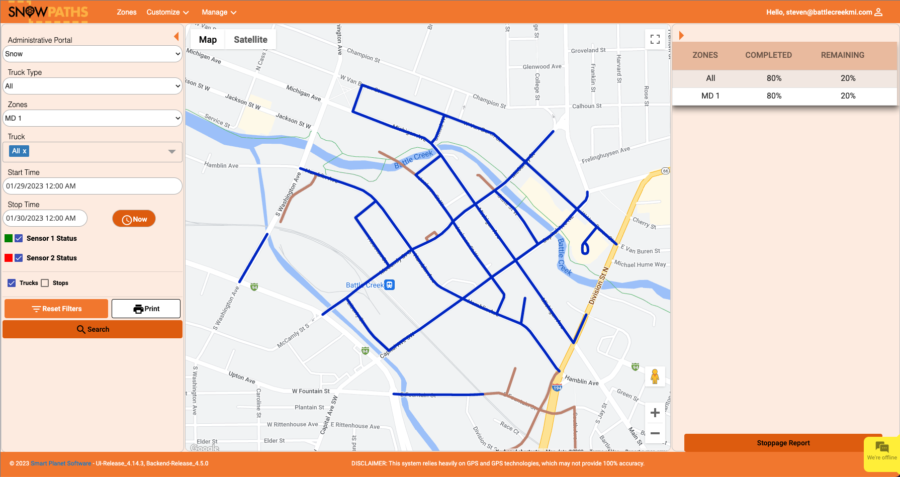
SnowPaths offers an intuitive management dashboard that provides complete visibility over your city’s fleet and their progress during snow events. Our dashboard is designed to be user-friendly, with easy access and quick navigation. With a powerful interface, all the information that your internal management needs is only a click away.

Beginning of Snow Event
  • Snow plows and plow routes are pre-loaded into SnowPaths
  • The management dashboard shows views of all the plows and routes activated
  • Visibility of percentage of the entire system ready and updated in real-time
  • Have all the detailed information ready to field incoming calls, for example, schools, local news, and city officials
During Snow Event
  • The management dashboard shows percentage of completion and remaining percentages for each active route in real-time
  • Run reports by truck type, truck name or number, by sections, start and stop times
  • View details on each truck such as location, direction and plow and spreader status
  • Easy mapping system of fleet and progress
  • View non-completed maps and routes
  • End of shift viewing and reporting to hand off to new shift
  • Compatible with Arc GIS and Esri Maps
End of Snow Event
  • Run reports on when plows were up and down
  • Run reports on salt spreaders and idle times
  • Replay one vehicle or entire fleet from a user define date and time
  • Use the detailed reporting system to increase productivity in future events
  • FleetPaths Supports
    Reveal, Network Fleet, Network
  • Includes Verizon’s extensive Roadside Assistance plan which provides services such as free towing
  • Track engine diagnostic trouble codes
  • Reliable, battery-powered tracking of fixed and movable fleet assets like trailers, shed, generators and heavy equipment
  • Over 20 different reports such as Geofencing,
    ELD and service records

Address List

Social Networks

Smart Planet Software

Building Intelligent Products

Scroll to Top